
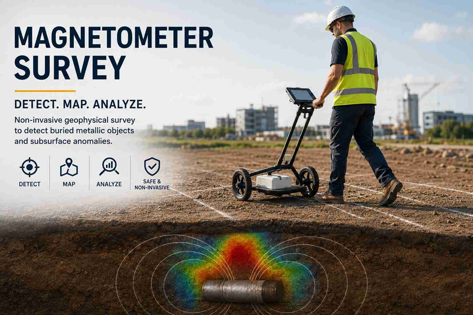
What Is a Magnetometer Survey?
A magnetometer survey is a non-invasive geophysical survey used to detect magnetic anomalies caused by buried or surface features. It can help locate ferrous pipes, tanks, drums, cables, metal debris and other underground targets without excavation. The collected data is mapped and analysed to identify potential subsurface features, making magnetic surveying useful for pre-construction, utility and land development projects.
How Does a Magnetometer Survey Work?
· Site Inspection – Check the area for magnetic interference from vehicles, fences and structures.
· Survey Control – Establish accurate coordinates using GNSS or total stations.
· Instrument Setup – Calibrate and configure the magnetometer for the survey.
· Data Collection – Record magnetic readings along planned survey lines or grids.
· Data Processing – Filter and correct readings to identify significant anomalies.
· Anomaly Analysis – Assess the location, strength and pattern of magnetic anomalies.
· Mapping & Reporting – Produce magnetic maps, coordinates and CAD/GIS outputs.
· Target Identification – Interpret anomalies to identify potential buried features or metallic objects.
What Is a Magnetometer Used For?
- Detect buried steel tanks, drums, pipes and ferrous debris
- Identify archaeological foundations, kilns, hearths and buried structures
- Support utility and infrastructure investigations
- Map magnetic geological and mineralised zones
- Identify potential buried hazards before excavation
- Support environmental site investigations
- Complement GPR and electromagnetic surveys for subsurface mapping
- Assist pre-construction and infrastructure surveys by locating potential underground targets
Types of Magnetometer Surveys
· Ground-Based Survey – Surveyors carry the magnetometer across grids or survey lines for detailed measurements on smaller or restricted sites.
· Drone-Based Survey – UAV-mounted sensors provide faster coverage across large or difficult-to-access areas.
· Vehicle-Towed Survey – Sensors are towed behind vehicles for efficient magnetic data collection across large, open sites.
· Marine Survey – Towed magnetometers are used to investigate subsea pipelines, shipwrecks, buried metallic objects and offshore cable routes.
· Survey Selection – The appropriate method depends on site size, accessibility, target depth, required resolution and project objectives.
Magnetometer vs. Gradiometer: What’s the Difference?
A magnetometer measures the magnetic field at the sensor location. A magnetic gradiometer uses two or more sensors to measure the difference in magnetic field between separated points.
This differential measurement can reduce the influence of some broad regional magnetic variations and improve the identification of relatively localised anomalies.
| Feature | Magnetometer | Gradiometer |
| Measurement | Magnetic field | Magnetic field gradient/difference |
| Sensor configuration | Single sensor or total-field arrangement | Multiple sensors |
| Main strength | Magnetic field mapping | Local anomaly detection |
| Shallow target detection | Depends on survey conditions | Often advantageous |
| Background variation | More apparent | Differential measurement can suppress some effects |
| Typical use | General magnetic investigation | Detailed anomaly mapping |
The choice should be based on the target, expected depth, site conditions, background magnetic environment and required resolution rather than simply selecting the most advanced instrument.
How Magnetometer Surveys Support Land Surveying Projects
Traditional land surveying establishes information such as boundaries, coordinates, elevations and existing surface features using equipment such as GNSS receivers, total stations and laser scanners.
A magnetometer addresses a different problem: identifying magnetic responses associated with subsurface or surface targets.
For this reason, magnetic surveying can complement conventional land surveying rather than replace it.
For example, a development site may require:
- Topographic surveying for existing ground levels
- Boundary or cadastral surveying
- Utility investigation
- GPR surveying
- Magnetometer surveying
- Control surveying
- As-built documentation
Combining these datasets in a common coordinate system allows survey and engineering teams to review surface and subsurface information together.
On complex sites, magnetometer data can also be incorporated into CAD and GIS environments, allowing detected anomalies to be plotted against site boundaries, proposed structures, roads and utility corridors.
Magnetometer Survey Equipment
· luxgate Magnetometers – Reliable sensors for ground-based magnetic surveys and gradiometer applications.
· Cesium Vapor Magnetometers – High-sensitivity equipment for detecting small magnetic variations.
· Proton Precession Magnetometers – Used for total-field magnetic measurements in geophysical surveys.
· Magnetic Gradiometer Arrays – Multiple sensors that improve anomaly detection and survey productivity.
· UAV-Mounted Magnetometers – Lightweight systems combined with GNSS positioning for large or difficult-to-access sites.
· Equipment Selection – Based on survey area, target type, terrain, sensor height, line spacing and required accuracy.
Factors That Can Affect Magnetometer Survey Accuracy
Magnetometer surveys are sensitive instruments, and site conditions can significantly influence the data.
Common sources of interference include:
- Vehicles and heavy machinery
- Steel fencing
- Reinforced concrete
- Metallic buildings
- Buried scrap
- Power infrastructure
- Temporary site equipment
- Magnetic geological formations
- Nearby metallic structures
- Poor positioning control
- Incorrect sensor height or survey spacing
Field teams therefore need to plan the survey around potential magnetic interference.
A strong anomaly does not automatically mean a specific buried object is present. Anomaly interpretation requires consideration of the magnetic signature, geometry, location, surrounding geology and other available site information.
Magnetometer Survey and GPR: Why Use Both?
- Magnetometer – Detects magnetic anomalies from ferrous and magnetically responsive targets.
- GPR – Detects subsurface structures, voids and objects through electromagnetic reflections.
- Combined Survey – Using both methods provides broader subsurface investigation and improves target assessment.
- Data Integration – Results can be combined with utility records, topographic data, GNSS control and CAD/GIS mapping.
- Method Selection – The suitable technique depends on the target type, ground conditions and survey objectives.
Need Land Survey Support?
Accurate Survey Work L.L.C provides professional land surveying services in the UAE for construction, infrastructure and development projects.
Our services include topographic surveys, boundary surveys, utility surveys, setting out surveys, as-built surveys, GPS surveying, control surveys and magnetometer surveys.
Contact us to discuss your land survey requirements and project needs.
