
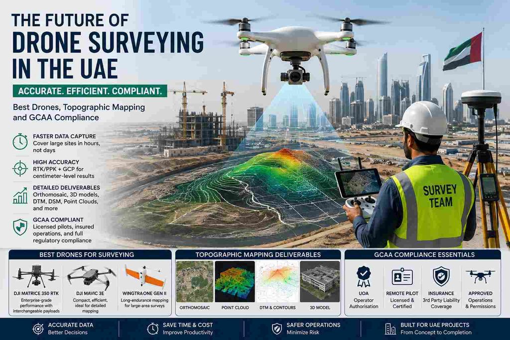
The UAE construction sector is sitting on a pipeline worth roughly $308 billion through 2030 (about $184B in Dubai, $87B in Abu Dhabi, $37B across the other five emirates), and the market itself is valued at around $44.5 billion in 2026, growing close to 5.6% a year. With over 11,000 active construction projects running at once across the country, surveyors simply can’t keep pace with total stations and foot traffic alone anymore. That’s where drones come in.
This guide breaks down everything you need to know about drone surveying in the UAE right now in plain, scannable points, not a wall of theory.
1. What Is a Drone Survey and How Does It Work in the UAE?
A drone survey is the process of using an unmanned aerial vehicle (UAV) fitted with cameras or LiDAR sensors to capture aerial data of a site, which is then processed into maps, models, and measurements.
How it actually works, step by step:
- A licensed pilot plans the flight path using mapping software (Pix4D, DroneDeploy, or similar), setting altitude, overlap %, and coverage area.
- The drone flies an automated grid pattern over the site, capturing hundreds or thousands of overlapping images.
- Ground Control Points (GCPs) are placed and measured beforehand using RTK GPS, so the final data lines up with real-world coordinates.
- The images are processed through photogrammetry software to build orthomosaics, 3D models, and point clouds.
- The output is handed to engineers, contractors, or government authorities as maps, DTMs (Digital Terrain Models), or volume reports.
Where it’s used across UAE projects:
- Pre-construction site assessment for towers, villas, and mixed-use developments in Dubai and Abu Dhabi
- Progress tracking on mega-projects like those tied to Etihad Rail’s 900 km network
- Land development and master planning in growth corridors such as Ras Al Khaimah and Sharjah
- Utility corridor mapping for pipelines, cables, and drainage networks
- Environmental and coastal monitoring along reclaimed land areas like Al Raha Beach and Palm developments
A drone survey typically takes a fraction of the time a ground crew would need a site that takes days on foot can often be flown in a few hours.
2. Why Drone Surveys Are Essential for Construction and Infrastructure Projects in the UAE
The UAE government alone has earmarked AED 240 billion for Abu Dhabi infrastructure over the next 7–10 years, covering housing, transport, healthcare, and education. Every one of those projects needs accurate survey data before a single foundation goes in.
For roads and transport:
- Faster corridor mapping for RTA-linked road and metro projects (RTA’s budget alone touched AED 27 billion for 2024–2026)
- Cross-section and profile data for road widening and realignment without shutting down traffic
- Drainage gradient checks across long stretches in a single flight
For buildings and towers:
- Site topography before excavation, cutting weeks off traditional survey timelines
- Facade and elevation capture for tall structures without scaffolding or rope access
- Progress monitoring — comparing weekly or monthly flights to track construction against the program
For utilities:
- Mapping existing utility corridors before trenching to avoid clashes
- As-built verification of buried and above-ground infrastructure
- Thermal imaging add-ons for leak or insulation detection on pipelines
For land development and large infrastructure:
- Master-planning large plots (hundreds of hectares) in a single day instead of weeks
- Cut-and-fill volume calculations for earthworks budgeting
- Flood-risk and drainage modeling using elevation data before design sign-off
Real, practical payoff: fewer site visits, faster design approvals, safer inspections (no one climbing a crane or walking a live road), and survey data accurate enough that consultants and government authorities accept it directly.
3. Best Drone for Surveying: Features to Look for in Professional Survey Drones
Not every drone is a survey drone. Here’s what actually matters when picking one for professional work in the UAE’s heat, dust, and open desert or dense urban settings.
RTK/PPK positioning
- RTK (Real-Time Kinematic) corrects GPS position live during flight, giving centimeter-level accuracy without needing as many GCPs
- PPK (Post-Processed Kinematic) corrects the data after the flight — useful when live signal is unreliable near tall buildings
- For UAE construction-grade work, RTK/PPK is non-negotiable; anything less won’t meet consultant or authority accuracy requirements
Camera quality
- Minimum 20MP sensor for orthomosaic and topographic work
- Global shutter cameras reduce distortion when flying fast over large sites
- Multispectral cameras add value for vegetation, land, and environmental studies
LiDAR compatibility
- LiDAR sees through vegetation and captures ground elevation even where the camera can’t — critical for the UAE’s landscaped developments and palm/desert terrain
- Needed for dense urban surveys where buildings and structures block photogrammetry
- Produces denser, more accurate point clouds than photos alone, especially for utility and drainage design
Flight time and battery
- 30–45+ minutes per battery is the practical minimum for covering large plots efficiently
- Hot UAE summers reduce battery life — always plan with a buffer, especially May to September
- Quick-swap battery systems keep large-site surveys moving without long downtime
Accuracy benchmarks to ask for
- Horizontal accuracy: 1–3 cm with RTK and good GCP placement
- Vertical accuracy: 2–5 cm, critical for contour and volume work
- Ask any drone survey company for their accuracy report — a professional outfit will hand it over without hesitation
Popular models used by UAE survey teams today include the DJI Matrice 350 RTK (with Zenmuse P1 or L2 payload for LiDAR), DJI Mavic 3 Enterprise, and fixed-wing options like the WingtraOne for very large land parcels.
4. Drone Topographic Survey: How It Creates Accurate Terrain and Contour Maps
A drone topographic survey turns thousands of aerial images or LiDAR points into a usable terrain model — the foundation almost every design decision on a project sits on.
How the terrain model gets built:
- Overlapping images (or LiDAR returns) are stitched into a dense 3D point cloud
- The point cloud is classified to separate ground points from vegetation, vehicles, and structures
- A Digital Terrain Model (DTM) is generated from the ground points — this represents the bare earth
- A Digital Surface Model (DSM) captures everything above ground too, including trees and rooftops
What comes out of it:
- Contour lines at whatever interval the project needs (commonly 0.25m or 0.5m for UAE design work)
- Elevation data accurate enough for road, drainage, and site grading design
- Cross-sections and longitudinal profiles pulled instantly from the model, without sending a crew back to site
- Cut-and-fill volume reports comparing existing ground to proposed design levels — this alone can save significant cost on earthworks budgeting for large plots
Why this matters practically:
- Contractors use it to plan exactly how much material to move, and where
- Consultants use it to check drainage falls before construction starts
- Developers use it to spot low points and flood risk zones early, before design lock-in
- Update flights during construction let everyone track how the ground is actually changing versus the plan
For flat desert plots or large land parcels, a single well-planned drone flight can replace what used to take a ground survey crew several days with total stations.
5. Drone Survey Equipment Used by Professional Surveyors in the UAE
A drone is only one piece of the kit. Here’s the full toolset a serious UAE survey team runs:
- Survey-grade drones — multirotor for tight or complex sites, fixed-wing for large open land parcels
- RTK base stations — set up on a known point to broadcast correction signals to the drone and rover in real time
- GNSS receivers/rovers — used to establish and check ground control points against UAE’s national coordinate system
- Ground Control Points (GCPs) — physical markers placed and measured before the flight so the final data ties into real-world coordinates with certified accuracy
- LiDAR payloads — for dense vegetation, utility corridors, and urban sites where photogrammetry alone struggles
- Processing software — Pix4Dmapper, Agisoft Metashape, or DJI Terra for turning raw images into orthomosaics, point clouds, and DTMs
- CAD/GIS software — AutoCAD Civil 3D, Global Mapper, or QGIS to turn the processed data into deliverable drawings and reports
- Total stations and levels — still used alongside drones for tight-tolerance work like building setting-out and control verification
A professional outfit doesn’t just own a drone — it runs the full chain from GCPs to final CAD deliverable, cross-checked at every step.
6. GCAA Compliance for Drone Surveying in the UAE
This is where a lot of projects get delayed or fined — flying without the right paperwork. The UAE runs one of the strictest drone regulatory environments in the region, split between the federal General Civil Aviation Authority (GCAA) and emirate-level bodies like the Dubai Civil Aviation Authority (DCAA).
What’s required for commercial survey flights:
- UAS Operator Certificate (UOC) — mandatory for any commercial drone activity, including surveying
- Remote Pilot License (RPL) — each pilot needs GCAA-approved training, a medical fitness check, and a practical flight exam
- Trade license — the company must hold a UAE trade license that specifically covers drone operations
- Aircraft registration — every drone used commercially must be individually registered under the UOC
- Third-party liability insurance — minimum AED 1,000,000 coverage per aircraft is required
- Site-specific flight approvals — permissions near airports, government buildings, and restricted zones go through GCAA’s DroneZone or DANS portal, and in Dubai, DCAA approval is a separate additional step
Why compliance actually matters, beyond avoiding fines:
- Flying without registration or a license can mean confiscation and fines running into tens of thousands of dirhams
- Flying in restricted airspace carries even steeper penalties, including possible imprisonment
- Government authorities and consultants in the UAE typically won’t accept survey data from an unlicensed operator — it simply won’t get approved on official submissions
- Insurance protects the client, not just the operator, if anything goes wrong on-site
Practical tip: before hiring anyone for a drone survey, ask to see their UOC and pilot RPLs directly. A legitimate operator will show these without being asked twice.
7. Choosing a Professional Drone Survey Company in the UAE
With this much construction activity in play, picking the right survey partner is not a small decision. Here’s what to actually check before signing off:
- GCAA/DCAA licensing — confirm the UOC and pilot RPLs are current, not expired
- Track record on similar projects — ask for references from comparable site types (roads, towers, utilities, land development)
- Equipment on hand — RTK-equipped drones, LiDAR availability, GNSS base stations, and proper GCP setup, not just a consumer drone with a nice camera
- Accuracy reports — a professional company can show you horizontal and vertical accuracy figures from past jobs, not just promise “high accuracy”
- Turnaround time — clarify how fast raw data becomes usable CAD/GIS deliverables
- In-house processing capability — teams that process their own data (rather than outsourcing) tend to catch errors faster and communicate better on revisions
- Combined survey capability — the best partners pair drone data with total station, GPS RTK, and 3D laser scanning so gaps in aerial coverage (like under structures or dense vegetation) still get filled accurately
Accurate Survey Work L.L.C. has been running land and engineering survey projects across Abu Dhabi and the wider UAE for over 11 years, with 60+ surveyors and 250+ completed projects for clients including RTA and Abu Dhabi Airport. Their drone mapping service pairs UAV data with certified topographical survey work, GPS RTK survey control, and control point verification — so the deliverable is design-ready, not just a pretty aerial photo. For sites with dense structures or vegetation where drones alone fall short, their 3D laser scanning service fills in the gaps.
If you’re planning a survey for a construction, infrastructure, or land development project anywhere in the UAE, it’s worth a quick call before the drone even leaves the ground — get in touch here.
