
A terrain model does more than show elevation—it helps engineers understand the ground, buildings, vegetation and terrain changes that can affect project design. DTM, DEM and DSM are often treated as the same, but each serves a different purpose: DTM focuses on the ground surface, DSM represents the surface including above-ground features, while DEM is a broader term for digital elevation data. The right choice depends on the project, with resolution, accuracy, data source and required level of detail all playing a role in selecting the most suitable terrain model.
DTM, DEM and DSM: The Basic Difference
Before getting into the technical details, this is the easiest way to separate them:
| Model | Mainly represents | Typical applications |
| DEM | Digital elevation information | GIS, terrain and regional analysis |
| DTM | Bare-earth terrain and terrain-defining features | Engineering, grading and infrastructure |
| DSM | Top surface including buildings, trees and other objects | 3D modelling, urban and surface analysis |
The terminology can vary between countries, software and data providers, so the dataset specification should always be checked before using it for engineering work. USGS specifically notes that DEM, DTM and DSM are not used with one universal definition across every workflow.
What Is a DEM?
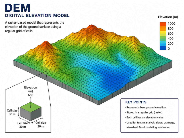
A Digital Elevation Model (DEM) is a digital representation of elevation across a particular area.
In a typical raster DEM, elevation values are arranged in a regular grid. Each cell represents a particular area and stores an elevation value. USGS describes DEMs as sampled elevation data arranged at regular positions, while also noting that different DEM products can have different surface definitions, resolutions and vertical references.
Where is DEM data used?
- Terrain analysis: DEM data can be used to study how elevation changes across a large area, making it useful for identifying slopes, valleys, ridges and other terrain patterns.
- Flood and drainage studies: Elevation data can help identify low-lying areas and potential surface-water flow paths before more detailed hydraulic or drainage modelling is carried out.
- GIS projects: DEMs can be combined with roads, land-use information, property boundaries and other GIS layers to understand how terrain relates to existing infrastructure and development.
- Environmental assessment: Large-area elevation datasets can support studies involving watersheds, erosion, terrain conditions and landscape characteristics.
What Is a DTM?
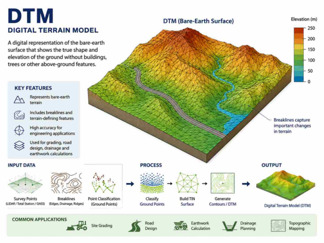
A Digital Terrain Model (DTM) is focused on the shape of the ground itself.
For engineering projects, this distinction is important because the design team usually needs to understand the terrain beneath buildings, vegetation and other surface objects.
USGS describes a DTM workflow as potentially including 3D mass points and breaklines, which can preserve important terrain features more effectively than a simple grid of elevation values.
Where is DTM used?
- Site grading: A DTM can represent the existing ground surface so engineers can compare it with proposed formation levels and determine where excavation or filling may be required.
- Road design: Road profiles and cross-sections depend on reliable ground elevations. A detailed terrain model helps the design team understand changes in elevation along the proposed alignment.
- Earthwork calculations: Existing and proposed surfaces can be compared to estimate cut-and-fill quantities, which can then support material planning and construction cost assessment.
- Drainage planning: Ground slope directly affects how surface water moves. A suitable terrain model can help identify low areas, changes in grade and natural drainage paths.
- Topographic mapping: Survey points and breaklines can be used to generate contours and other terrain information that show the existing condition of a site.
What Is a DSM?
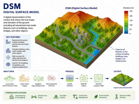
A Digital Surface Model (DSM) represents the upper surface detected by the survey or mapping system.
Unlike a bare-earth model, a DSM can include features above the ground such as:
- Buildings
- Trees
- Towers
- Roofs
- Vegetation
- Bridges
- Other structures
USGS identifies DSMs as useful for applications such as telecommunications, forestry, air-safety studies and 3D modelling.
Where is DSM used?
- Building-height analysis: A DSM can show the elevation of building roofs and other elevated structures, allowing analysts to study building heights across an area.
- Solar studies: Buildings, trees and other objects can affect sunlight reaching a roof or open area. DSM data can help identify these surface obstructions.
- Telecommunication planning: Towers, buildings and vegetation can interfere with signal paths. A DSM provides surface information that can support line-of-sight and obstruction analysis.
- 3D city modelling: Because buildings and vegetation remain represented, DSM data can provide a more realistic model of an urban environment.
- Vegetation analysis: When DSM and ground-terrain data are compared, the height of vegetation or other objects above the ground can be estimated.
DTM, DEM or DSM: Which One Should You Us
Choose the model based on what your project needs to measure.
- Land development — DTM: Best suited for existing-ground levels, grading, contours, drainage and site planning.
- Road & infrastructure — DTM: Useful for ground profiles, alignment, embankments and terrain changes along the corridor.
- Earthwork calculations — DTM: Compare existing and proposed surfaces to estimate cut-and-fill quantities.
- Urban & building analysis — DSM: Useful when buildings, trees and other above-ground features need to be included.
- Regional GIS analysis — DEM: Suitable for large-area terrain, environmental and GIS studies where detailed site-level data is not required.
Why Resolution Matters
Resolution determines how much terrain detail a model can capture.
- Coarse resolution: Useful for regional terrain and GIS studies but may miss small features such as kerbs, drains and local grade changes.
- High resolution: Better suited for detailed site work where precise ground features are important.
- For engineering projects: Always check the model’s resolution and accuracy before using it for design or quantity calculations.
A Real-World Elevation Dataset: Copernicus DEM
Copernicus DEM is a useful example of why understanding the source matters.
The official Copernicus documentation identifies its DEM as a Digital Surface Model, representing the Earth’s surface including buildings, infrastructure and vegetation. The product is available in different resolutions, including GLO-30 and GLO-90 global products.
This type of dataset can be valuable for:
- Regional terrain analysis
- GIS applications
- Mapping
- Environmental studies
- Large-area planning
But a global elevation dataset should not automatically be treated as a replacement for a detailed project survey.
A construction project may require much more specific information about survey control, local ground features, breaklines, vertical accuracy and current site conditions.
Official reference: Copernicus DEM Product Documentation
How Survey Data Becomes a Terrain Model
A terrain model is built by collecting accurate site measurements and processing them into a usable ground surface.
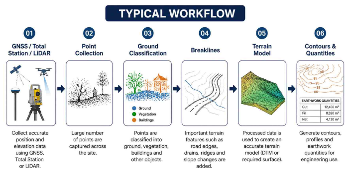
- Field survey: Collects accurate elevation and position data across the site.
- Ground classification: Separates ground points from buildings, vegetation and other objects.
- Breaklines: Captures important features such as road edges, drains, ridges and slope changes.
- Surface creation: Processes the survey data into a DTM or other required terrain model.
- Engineering use: The final model supports contours, profiles, grading, drainage and earthwork calculations.
A detailed topographic survey provides the site data needed to build a reliable terrain model
What Should You Check Before Using a Terrain Model?
- Surface type: Check whether the data represents bare ground, buildings and vegetation, or a general elevation surface.
- Resolution: Confirm the grid size or point density to make sure it captures the level of detail your project needs.
- Accuracy: Check the stated horizontal and vertical accuracy before using the data for engineering calculations.
- Coordinate system: Make sure the terrain model matches the coordinate system used for your survey and design data.
- Vertical datum: Confirm the elevation reference before combining data from different sources.
- Capture date: Use recent data where site conditions may have changed due to construction, excavation or development.
- Data source: Check whether the model comes from LiDAR, photogrammetry, satellite data, GNSS or total station surveying.
Need Accurate Terrain Data for Your Project?
Accurate Survey Work L.L.C supports construction and land-development projects with land surveying, topographic surveying, GPS/GNSS surveying, total station surveying and other site measurement services in the UAE.
