
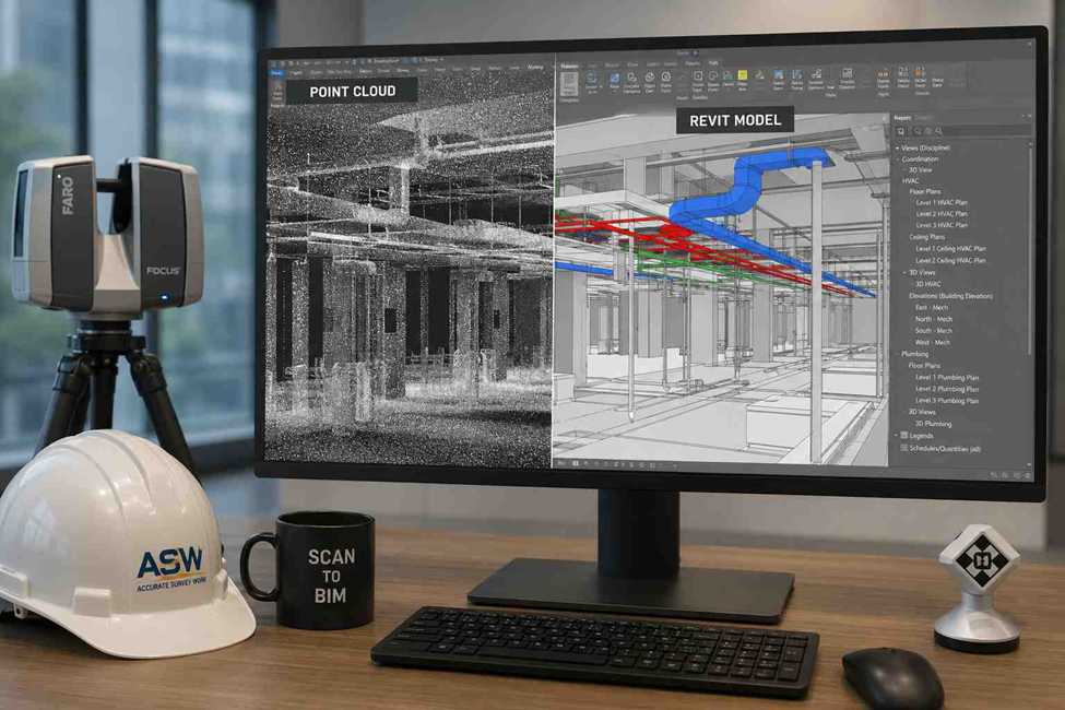
Old buildings rarely come with accurate drawings. Renovation plans, MEP coordination, and facility management all stall when the “as-built” file doesn’t match what’s actually on site. Scan to BIM closes that gap — a proper 3D laser scanning service turns a point cloud into a working Revit model your design and construction teams can actually use. In the UAE, where fast-moving retrofit and expansion projects are the norm, that Point Cloud to Revit Modeling step has become standard practice rather than a nice-to-have.
What Scan to BIM Actually Means
A 3D laser scanner captures millions of measured points off a building’s surfaces — walls, ceilings, ducts, pipework, structural members. That raw point cloud isn’t a model; it’s a dense photograph made of coordinates. Scan to BIM is the process of tracing intelligent, parametric Revit elements — walls with real thickness, doors with real swing, ducts with real diameters — directly on top of that point cloud, so the final file behaves like a proper BIM model instead of a static 3D scan.
How the Workflow Runs, Step by Step
1. Field capture. A terrestrial laser scanner (or LiDAR survey unit) is set up at multiple stations around the site to capture full coverage without blind spots. This is the core of any laser scanning survey in the UAE — each scan records geometry as a dense XYZ point set.
2. Control and registration. Scans are tied together using survey control — a GNSS survey or Total Station survey — so the combined point cloud sits on real-world coordinates instead of floating in local space. This is standard land survey practice in the UAE, and it’s what makes the model usable for site coordination later.
3. Cloud cleanup. Overlapping scans get registered, noise and stray points get stripped out, and the cloud is classified by element type. This point cloud processing stage — a core piece of any reality capture service — usually runs through Autodesk ReCap, producing a clean, aligned dataset ready to bring into Revit.
4. Modeling in Revit. Modelers build architectural, structural, and MEP elements directly against the point cloud reference. This is where Revit BIM modeling turns raw geometry into a discipline-coordinated model with real parametric data behind every wall, column, and duct run — not just lines that look right.
What You Actually Get
- Architectural model — walls, doors, windows, finishes, floor-to-floor heights
- Structural model — columns, beams, slabs, load-bearing elements
- MEP model — HVAC runs, electrical containment, plumbing networks
Each one is dimensionally accurate against the physical building, not against an old drawing set that may have drifted from reality over several rounds of change — which is really the whole point of as-built BIM modeling.
Where It’s Actually Used
- Renovation and retrofit design, where the existing structure has to be trusted
- Clash detection before new MEP routing goes in
- Facility management and space planning
- Heritage building documentation
- Digital twin modeling for ongoing asset management
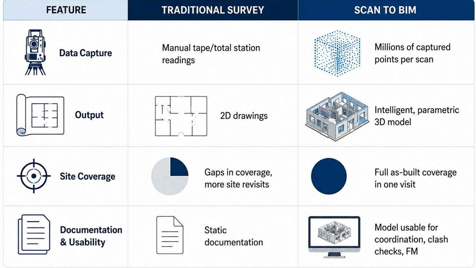
Scan to BIM vs. Traditional Site Survey
Where Accuracy Comes From
The output is only as good as the survey control behind it. Loose registration or unverified control points show up later as clashes on site — which defeats the purpose of BIM coordination services in the first place. This is where working with a land survey company in the UAE that runs the control alongside the scanning, rather than treating them as separate jobs, actually matters. It’s also the reason ISO 19650, the international standard for managing BIM information across a project lifecycle, puts so much weight on defined information requirements before modeling starts — accuracy has to be specified up front, not checked after the fact.
FAQ
Is a Scan to BIM model the same as a raw laser scan? No. The scan is just captured geometry. Scan to BIM adds the modeling layer — parametric Revit elements built to match it.
Can it produce as-built documentation for a building with no existing drawings? Yes — that’s one of the main use cases. The point cloud replaces the missing drawing set as the source of truth.
What software is involved? Point cloud registration typically runs through Autodesk ReCap; modeling happens in Revit.
How accurate is it? Well-executed scan to BIM work typically holds to a few millimeters, provided the survey control behind the registration is sound.
Get in touch with Accurate Survey Work L.L.C for scan to BIM, survey control, and Revit modeling handled as one coordinated process. The team also covers topographic survey, land survey, and pre-construction survey work across the UAE.
