
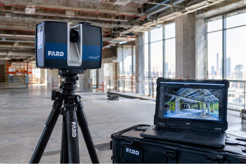
When an existing building, industrial facility or construction site needs to be measured in detail, conventional measurements may not always provide enough information. Complex structures, equipment, services and difficult-to-access areas can make it difficult to record every important feature manually.
A FARO 3D laser scanner provides a different approach by capturing a large amount of three-dimensional information from the surrounding environment. The collected data can then be processed and used for surveying, design, construction coordination, as-built documentation and other project requirements.
FARO 3D Laser Scanner: What It Does, Why It Matters and Where It Fits
A FARO 3D laser scanner is used to capture detailed measurements of buildings, structures, equipment and other physical spaces. Instead of measuring every surface manually, the scanner records a large number of points from different positions and creates a detailed digital representation of the surveyed area.
This makes FARO scanning particularly useful when the existing condition of a site needs to be documented accurately. It can support renovation work, engineering design, as-built documentation, industrial modifications and other projects where reliable site information is important.
FARO 3D Laser Scanner for Existing Buildings
Existing buildings can change considerably over their lifetime. Partitions may be moved, services added and spaces modified, while the original drawings may remain unchanged. A current scan can provide a more useful picture of the building as it exists today.
The captured data can support architects, engineers and contractors when planning refurbishment or modification work. It can also help reduce repeated manual measurements when detailed information about walls, floors, ceilings and visible building elements is required.
FARO 3D Laser Scanner for Industrial Sites
Industrial facilities often contain pipes, machinery, platforms, cable trays and structural components within relatively limited spaces. These conditions can make conventional measurement work more complicated, especially when several systems need to be coordinated.
Laser scanning can capture visible elements from multiple positions and combine them into a common dataset. This information can then support plant modifications, equipment replacement, pipe routing, structural additions and coordination of new installations.
How Is a FARO Laser Scanning Survey Carried Out?
The survey normally begins with a review of the site and the information required by the client. The surveyor considers the area to be captured, access conditions, obstructions, required accuracy and final deliverables before deciding where scanner positions should be established.
The scanner is then placed at suitable locations around the site to capture the required areas. Multiple positions may be needed because walls, columns and machinery can block the scanner’s view, while overlapping information between positions helps the individual scans to be combined later.
Why Is Scanner Position Important?
A laser scanner can only capture what it can see. If a large machine blocks a pipe or a structural element hides part of a wall, that information may not be captured from the original scanner position.
For this reason, surveyors plan scanner locations carefully and may use additional positions to capture hidden areas. Good planning also provides sufficient overlap between scans, which helps during the registration and checking stage.
What Happens to the Scan Data?
The individual scans collected from different positions are normally registered together to create one coordinated dataset. This process brings the separate scan positions into the same spatial reference so that the surveyed environment can be viewed as a complete point cloud.
After registration, the data can be checked and processed according to the project requirement. Depending on the scope, the information may be used to prepare measurements, CAD drawings, sections, elevations, as-built documentation or 3D models.
Point Cloud and 3D Model: Are They the Same?
A point cloud is a collection of measured points representing the surfaces captured during the survey. It provides detailed spatial information but does not automatically mean that the building or structure has been converted into a fully modelled digital object.
A 3D model is created by interpreting the survey information and developing elements such as walls, floors, structural members or MEP components. The level of modelling required depends on the intended use and the project’s required level of detail.
FARO Scanning for As-Built Surveys
As-built scanning can be used to record the condition of a building or structure after construction or installation work has been completed. This provides a detailed reference that can be useful when future modifications or maintenance work is planned.
The information can also help project teams compare existing conditions with design information. For complex installations, having a detailed digital record can reduce the need to rely only on photographs or older drawings when planning future work.
Can FARO Scanning Work With Total Station and GNSS?
Laser scanning does not necessarily replace conventional surveying equipment. Total Stations and GNSS equipment can still be useful for establishing control, obtaining coordinates, checking positions and carrying out setting-out work.
Using different technologies on the same project can provide a more complete survey solution. Laser scanning can capture detailed geometry, while conventional survey instruments can provide controlled coordinates and reference information where required.
What Should Be Included in a Laser Scanning Survey?
The scope should clearly state what areas need to be scanned and what information the client expects at the end of the project. The survey team should also understand the required accuracy, coordinate system, access conditions and intended use of the data.
The final deliverables may include registered point clouds, CAD drawings, floor plans, sections, elevations, measurements, as-built drawings or BIM-related information. Defining these requirements before the survey helps avoid confusion after the fieldwork is completed.
Conclusion
A FARO 3D laser scanner provides a practical way to capture detailed information about existing buildings, structures, industrial facilities and other environments. Instead of relying only on individual measurements, the survey creates a broader three-dimensional record that can later be examined and measured.
The scanner itself is only one part of a successful survey. Proper site planning, scanner positioning, data registration, quality checking and suitable final deliverables are all important. When these elements are handled carefully, FARO laser scanning can provide useful information for design, construction, coordination and future documentation.
Frequently Asked Questions
What is a FARO 3D laser scanner?
A FARO 3D laser scanner captures detailed three-dimensional measurements of buildings, structures and physical environments.
Can FARO scanners be used for building surveys?
Yes, they can capture walls, floors, ceilings, structures and other visible building elements.The information can support renovation, modification and as-built documentation.
Does FARO scanning replace Total Station surveying?
Not always. Both technologies have different uses and can be used together on the same project.
Can FARO scan data be used for BIM?
Yes. Registered point cloud data can be used as a reference for creating BIM models.
How many scan positions are required?
There is no fixed number because it depends on the site size, layout, obstructions and required coverage.
Is a point cloud a 3D model?
No. A point cloud contains measured points, while a 3D model represents surveyed elements as digital objects or surfaces.
