
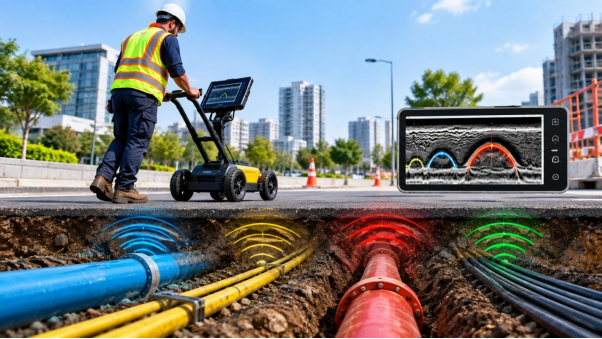
On paper, the plot is clear. The drawings show one water line along the boundary and a power cable near the road. Then the first trench opens and there is a second pipe nobody mentioned, running at an angle across the whole width of the site.
Situations like this are common, and they are why careful teams check the ground before they trust the records.
What Is an Underground Utility Survey?
An underground utility survey is the process of finding buried services, such as water, sewer, power and telecom lines, and recording where they run and how deep they sit. The work has two parts. Detection is the field work of locating the services with instruments. The survey part measures their positions accurately and turns them into a drawing the project team can use.
A proper utility survey covers both. Detection without accurate measurement leaves you with paint marks that fade, and measurement without detection leaves you with a drawing that only repeats the old records.
Why Utility Detection Is Needed Before Excavation
Records show where services were meant to go, not always where they ended up. Lines get diverted during repairs, new connections are added without updating the plans, and old services are left in the ground when they are replaced.
When a team digs without checking, a single strike can cost a day or more. A damaged cable can cut power, a broken water line can flood the trench, and the crew can be put at risk. Even when nothing is hit, finding an unexpected pipe mid-excavation often forces a redesign on the spot, which is far more expensive than adjusting a drawing in advance.
Methods Used to Detect Underground Utilities
No single instrument finds everything, so survey teams usually combine a few:
- Ground penetrating radar (GPR): Picks up pipes, ducts and voids by reflecting radio pulses off them. It can detect plastic and concrete services as well as metal ones, which makes it useful where materials are mixed.
- Electromagnetic cable locators: Trace metal pipes and live cables by detecting the signal they carry or conduct. They are quick and reliable for metallic lines but cannot see plastic ones.
- Trial trenching: A small, careful excavation at a chosen point to confirm what a reading shows. It is slower, so it is used where a result is doubtful or critical.
Each method has a blind spot, and the others cover it. Soil also matters, since wet, salty or clay-heavy ground can weaken radar results.
From Site Scan to Utility Drawing
Once detection starts, the work follows a steady order:
- Marking: Each service is marked on the ground as it is found, so the site team can see it straight away.
- Measuring: A total station or GNSS receiver fixes the marks to accurate coordinates.
- Processing: The field data is checked, and readings that don’t agree are rechecked on site.
- Drawing: The results are drawn up as a CAD utility plan showing each service’s position and approximate depth.
The plan is most useful when it sits on a base drawing. Combined with a topographic survey, the design team sees ground levels and buried services together and can plan trenches and foundations around them.
Choosing a Reliable Utility Survey Provider
Two utility survey providers can scan the same site and hand back very different drawings. A few questions help separate them:
- Do they use more than one detection method, or only radar?
- Do they confirm doubtful readings, for example with a trial trench?
- Do they fix positions with survey-grade equipment, not just mark the ground?
- Do they deliver a CAD drawing you can open and design on?
- Are they open about what ground conditions might limit the results?
A provider who answers these plainly, including the limits of the method, is usually more trustworthy than one who promises to find everything.
Conclusion
Underground utility survey and detection takes the guesswork out of excavation. When buried services are located and drawn before work begins, the design can be adjusted calmly instead of under pressure in the trench. If you are planning ground works in Abu Dhabi, a professional underground utility survey before design is a sensible first step, and you can get in touch with Accurate Survey Work to talk through your site.
Frequently Asked Questions
1. What is the difference between utility survey and utility detection?
Detection is the field work of finding buried services with instruments. The survey adds accurate measurement and drawing, so the results can be used for design and excavation planning.
2. Can all underground utilities be detected?
Most can, but not always with one method. Metal services respond well to electromagnetic locators, while plastic and concrete ones need radar. Very deep services and difficult soil can still limit results.
3. Is underground utility detection safe for the ground and nearby services?
Yes. Radar and electromagnetic locating are non-destructive, so nothing is dug up or disturbed during scanning.
4. When should the survey be done?
Before the design is finalized and well before excavation begins, so any findings can still be built into the drawings.
5. What will I receive after the survey?
A utility drawing, usually in CAD, showing the detected services with their positions and approximate depths, tied to the site coordinates.
