
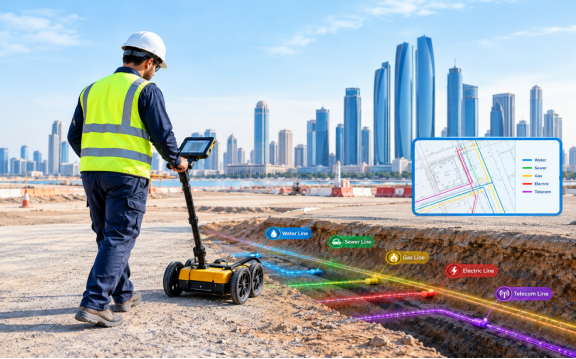
A site may look ready for excavation, but the ground below often hides water pipes, power cables, drainage lines and communication networks. If these are not identified early, a routine dig can turn into costly repairs, delays and safety risks.
This is where utility mapping and Subsurface Utility Engineering (SUE) help. For projects in Abu Dhabi and across the UAE, they give teams reliable underground information before design and construction decisions are made.
What Is Utility Mapping and SUE?
Utility mapping is the process of locating, measuring and recording underground services so they appear on technical drawings or digital maps. SUE is a wider engineering process that investigates underground utilities and rates how reliable the collected information is. In simple terms, mapping records where utilities are, while SUE also checks how much that information can be trusted.
Why Underground Utility Information Matters
Old drawings can be incomplete or wrong. A new foundation may clash with a buried pipe, or a road upgrade may cross an unknown cable route. Good utility data helps teams plan excavation more carefully and spot design conflicts before construction starts. It also improves coordination between consultants, contractors and service providers, and reduces utility damage and project delays.
The Four Quality Levels Used in SUE
SUE rates utility information on four levels, so teams know what is confirmed and what still needs checking.
Quality Level D: Existing Records
This level is based on old drawings, asset databases and records from relevant organisations. It suits early planning, but records can be outdated or approximate.
Quality Level C: Surveyed Visible Features
Records are checked against surveyed surface features such as manholes, valve covers and hydrants. The underground route between them may still be uncertain.
Quality Level B: Geophysical Investigation
Tools like Ground Penetrating Radar (GPR) and electromagnetic detection trace utilities without routine digging. Results vary with soil, depth, materials and interference.
Quality Level A: Physical Verification
The utility is carefully exposed, often by vacuum excavation, to confirm its exact position, depth, size and material. It is usually kept for critical spots such as crossings and congested corridors.
How Utility Mapping and SUE Are Carried Out
The work follows a planned sequence rather than relying on one instrument. It starts by reviewing drawings, asset data and earlier surveys to find known services and gaps. Survey professionals then inspect the site to identify visible utility features, access conditions and surface materials.
Next, GPR and electromagnetic locators are used together to detect and trace buried services, since each gives different information. The positions found are measured with Total Stations or GNSS instruments and tied to a coordinate system. Where more certainty is needed, selected utilities are exposed and verified. Finally, the data is turned into clear drawings, plans or digital datasets that separate verified positions from estimated ones.
Technologies Behind Modern Utility Investigations
GPR uses radar signals to find buried services, while electromagnetic detection traces conductive utilities. Total Stations and GNSS measure utility positions against survey control, and CAD and GIS mapping organise the results into drawings and spatial datasets. No single tool finds every utility in every condition, so combining methods works best.
Where Utility Mapping and SUE Are Used
These services are useful on road and transport projects, where services must be found before widening or resurfacing. They also help building and property developments avoid clashes with foundations, basements and drainage. Water and drainage projects use them to plan new pipelines and connections, commercial and industrial sites use them to trace crowded service routes, and infrastructure upgrades rely on them to support maintenance and future development.
Common Challenges and How to Handle Them
Old drawings may miss past changes, congested sites can blur signals, and depth, materials or restricted access can limit detection. Careful record review, mixed detection methods and verification at key points help, and clear reporting shows designers the limits of the data.
Conclusion
Utility mapping and SUE help teams move past assumptions and understand what lies underground. By combining records, detection, precise surveying and targeted verification, they support better design coordination and safer construction planning. Starting early reduces uncertainty.
Accurate Survey Work LLC (ASW) is a survey company in Abu Dhabi. It supports projects with utility survey and underground mapping work, drone mapping, mobile mapping and CAD services.
Frequently Asked Questions
What does SUE stand for in utility mapping?
SUE stands for Subsurface Utility Engineering, a method for investigating underground utilities.
Is utility mapping the same as SUE?
No. Utility mapping records utility locations, while SUE also checks how reliable that information is.
Can GPR locate every underground utility?
No. Results depend on ground conditions, depth and utility type, so GPR is usually combined with other methods.
Why is Quality Level A important?
It confirms a utility’s exact position and depth by exposing it at critical locations.
When should utility mapping be completed?
Early, before design is finalised, with a quick check before excavation.
