
Before you pour a single foundation, you need to know exactly where your land actually sits not where you think it sits based on an old drawing or a fence someone put up years ago. That’s what land demarcation, sometimes called area demarcation, is for.
What Is Land Demarcation, and Why Does It Matter in Abu Dhabi?
Land demarcation is the process of physically marking out a plot’s official boundaries on the ground, based on approved survey records and coordinates. In Abu Dhabi, this usually means a licensed surveyor visits the site, checks the plot data approved by the Department of Municipalities and Transport (DMT), and pins down exactly where your property starts and ends.
It sounds simple, but it’s one of those steps that quietly protects everything that comes after it your design, your approvals, your relationship with the neighbours.
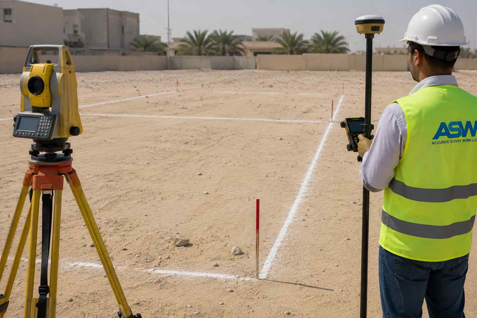
Surveyors typically use GNSS equipment, Total Stations, and established survey control points to transfer the coordinates from official records onto the actual site. The result is a clear, verified picture of your plot’s real limits.
A few reasons this step matters more than people expect:
- It confirms exactly where your boundaries fall on-site, not just on paper
- It gives architects and engineers something solid to design around
- It heads off boundary disputes with neighbouring plots before they start
- It gives authorities reliable data to work from during approvals
- It protects your ownership record over the long term
Whether you call it land demarcation or area demarcation, the goal is the same: a plot with clearly defined, verified limits before anyone starts designing or building on it.
How Accurate Demarcation Saves You From Delays Later
Here’s the thing about boundary errors — they rarely show up early, when they’re cheap to fix. They show up mid-construction, when a wall is already partway up or a setback has already been designed around the wrong line.
Skip proper demarcation and you’re gambling with a few things: disputes with neighbours over where the line actually is, holdups in getting your project approved, extra survey and redesign costs you didn’t budget for, and in the worst cases, having to move a structure that’s crept over the boundary.
Get the demarcation done properly before construction starts, and your whole project team is working from the same verified numbers. That alone avoids a lot of the back-and-forth that eats into a project’s timeline.
How the Land Demarcation Process Works, Step by Step
1. Reviewing what already exists
The survey team starts by pulling together everything already on record — plot plans, ownership documents, past survey drawings, and approved land data. This gives them a reference point before anyone sets foot on site.
2. Taking measurements on-site
Next, surveyors head to the property with GNSS equipment and Total Stations, working off established survey control networks. The measurements they collect get checked against the approved coordinates to pinpoint exactly where the boundaries fall.
3. Marking the boundaries
Once the verification is done, the boundary points get marked clearly on the ground. From here, everyone architects, contractors, engineers has a fixed reference for building layout, boundary walls, and site infrastructure. All measurements are referenced to the Abu Dhabi Coordinate System, in line with DMT’s surveying standards.
4. Handing over the survey report
The final step is a report that lays out the confirmed boundary data. This becomes the reference document your consultants and contractors will lean on throughout planning and construction.
| Stage | What Happens | What You Get |
| 1. Record review | Team checks plot plans, ownership documents, and approved land data | A verified reference point before any site visit |
| 2. Site measurement | GNSS and Total Station readings taken on-site, checked against approved coordinates | Confirmed boundary positions |
| 3. Boundary marking | Boundary points marked physically on the ground | Clear on-site reference for design and construction |
| 4. Survey report | Final documentation prepared | A report your consultants and contractors can rely on |
Mistakes Worth Avoiding Before You Start Building
Trusting an old drawing. Plots get subdivided, ownership changes, land gets modified a drawing from a few years back may no longer reflect what’s actually approved today.
Starting work before boundaries are confirmed. It’s tempting to get moving, but starting without a verified survey is how you end up paying for corrections later.
Relying on visible markers instead of proper survey control. A fence or an old boundary stone isn’t proof of anything only coordinate-based verification is.
Not re-surveying after a plot changes. Any extension, subdivision, or adjustment to a plot should be followed by an updated survey — the old one no longer applies.
Why Bring In a Professional Survey Team
A qualified land demarcation team doesn’t just mark corners they verify everything against approved coordinates and hand you documentation that actually holds up when it’s needed for approvals or disputes. That means fewer surprises mid-project, a design team working from solid data, and a paper trail you can point to if a boundary question ever comes up years down the line.
When Should You Get a Demarcation Survey Done?
It’s worth doing before you:
- Start a new construction project
- Build a boundary wall or fence
- Buy or transfer land
- Subdivide or merge plots
- Plan utility or infrastructure works
- Finalise your site development design
Getting it done early means every decision after that point is based on real, verified boundaries — not assumptions.
FAQs
How long does a land demarcation survey take in Abu Dhabi? It depends on the plot size and how complex the site is, but most standard residential or commercial plots can be surveyed and marked within a few working days.
Do I need a new demarcation survey if I already have an old boundary drawing? If the drawing predates recent land changes, subdivisions, or ownership transfers, yes — it’s worth getting it re-verified rather than relying on outdated data.
Can demarcation surveys help resolve a boundary dispute with a neighbour? Yes. Coordinate-based demarcation gives both parties a verified, documented reference point, which is usually the fastest way to settle a disagreement over where a line actually falls.
Is land demarcation required before getting construction approvals? Yes. Building permits and construction approvals in Abu Dhabi are processed through TAMM, the emirate’s government services platform, and accurate, verified boundary data is expected as part of that process — so it’s best to have demarcation done early rather than scrambling for it later.
What equipment do surveyors use for demarcation in Abu Dhabi? Most professional teams rely on GNSS systems, Total Stations, and established survey control points to transfer approved coordinates onto the physical site accurately.
Is area demarcation the same as land demarcation? Yes, they’re used interchangeably. Both refer to the process of marking out a plot’s verified boundaries on-site based on approved survey coordinates.
Need a Trusted Land Surveying Partner?
ASW Abu Dhabi (Accurate Survey Work L.L.C.) delivers professional land and area demarcation services across Abu Dhabi using advanced GNSS, Total Station, and survey control technologies. Our licensed surveyors provide accurate boundary verification, reliable survey documentation, and coordinate-based measurements to support residential, commercial, and infrastructure developments.
