
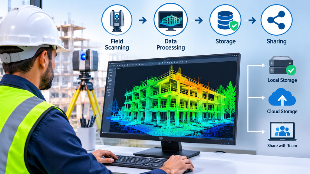
The scanner leaves the site, but the work is not finished. A scanning survey delivers data in large volumes, and the way you handle that data decides how useful it becomes. Many teams receive a point cloud, struggle to open it and end up using only a fraction of what they paid for.
This article covers what happens to scanning survey data after the fieldwork. It explains the formats, how to prepare and share the data, how to keep it secure and how to reuse it on later stages of a project.
Understanding Scanning Survey Data: What the Point Cloud Contains
A scanning survey records millions of points. Each point holds three coordinates and often a colour value and an intensity value, which describes how strongly the surface returned the laser. Many scanners also capture panoramic photographs from each station.
The point cloud is a measured record, not a model. It shows surfaces exactly as the scanner saw them, with all their gaps and clutter. The FARO 3D laser scanner article explains the difference between a point cloud and a 3D model in more detail. Understanding that difference helps you decide what you need next.
File Formats and Sizes: Planning for Large Datasets
Point clouds travel in several formats. E57 is a vendor-neutral format that most software can read. LAS and its compressed version, LAZ, are common in survey work. RCP and RCS open directly in Autodesk products. Text formats such as PTS and XYZ are simple but very large.
Size is the practical challenge. A full dataset can reach many gigabytes, and a standard office computer may struggle to open it. Before the survey, ask the provider about the size of the files and the software and hardware you will need. A reduced or cropped version of the data often solves the problem for people who do not need every point. The 3D laser scanning guide lists the deliverables a scan can produce.
Cleaning and Preparing Point Cloud Data for Use
Raw scan data contains unwanted points. People and vehicles pass through the scene, glass and shiny surfaces create false readings, and dust adds noise. The survey team removes these points during processing, so the final cloud reflects the structure and not the day of the scan.
Preparation also includes registration, which joins the separate scans, and the tie to survey control. The article on the 3D laser scanning process describes these stages. Ask the provider to confirm that cleaning and registration are complete before you accept the data.
Viewing and Sharing Scanning Survey Data with Project Teams
Not every team member needs the full point cloud. Designers may need it in their modelling software. Managers and clients may only need to look at the site and take simple measurements.
Free desktop viewers and web-based viewers let non-specialists explore the data in a browser, without special software. Providers can also supply panoramic views that work like a virtual walk-through. Choose the sharing method that fits each audience. For example, send the full cloud to the design team and a lightweight web view to the client.
Data Security, Privacy and Confidentiality
Scanning data can contain sensitive information. A scan of a building records its layout, its services and sometimes its security arrangements. Panoramic photographs may also capture people, faces, vehicle plates and screens.
Agree the rules before the survey. Decide who may access the data, how the provider will transfer it and when the provider must delete its own copies. Blur or remove personal details from images before you share them widely. For projects with sensitive facilities, confirm any extra restrictions with the owner. The UAE government portal publishes guidance on the country’s data protection rules, which apply to personal data in images.
Storage, Backup and Version Control
Large files need a plan. Keep at least two copies in different places, and store the original delivery separately from any edited versions. Name files clearly, with the project, the area, the date and the version. A simple naming rule prevents the common problem of several teams working from different copies.
Record the coordinate system and the control used in a short note stored with the data. Years later, that note saves hours of detective work. Also keep the survey report, because it documents the accuracy checks.
Reusing Scanning Survey Data on Future Project Stages
A well-managed dataset keeps its value long after the first use. The same point cloud can support a CAD drawing, then a model for design, then a record for facility management. Teams that preserve the data avoid paying for a second survey.
Reuse depends on the original control. Data tied to proper control points can combine with later surveys, so you can compare the site before and after a change. If the project needs a model, the scan to BIM service builds one from the existing cloud.
Reuse also has limits. A scan records the site on the day of the survey. If the building changes significantly, plan an update scan of the affected areas.
Conclusion
The value of a scanning survey continues long after the scanner leaves the site. Agree the formats and file sizes in advance, check that the provider has cleaned and registered the data, share it in a form each person can use and keep it secure. Store it with clear notes and plan to reuse it. These habits turn a large dataset into a lasting project asset. To plan a survey with ASW, start from the 3D laser scanning service page.
Frequently Asked Questions
What is scanning survey data?
It is a point cloud of measured points, often with colour and panoramic photographs, that records the surfaces of a site.
Which file formats do scanning surveys use?
Common formats include E57, LAS or LAZ and RCP. Ask the provider for the format that suits your software.
Why are point cloud files so large?
Each scan holds millions of points, so a full dataset can reach many gigabytes. A reduced or cropped copy is easier to share.
Can I share a point cloud with someone without special software?
Yes. Web-based viewers and panoramic views let non-specialists look at the data in a browser.
How long should I keep scanning survey data?
Keep it for the life of the project and ideally longer. Store a backup, the coordinate system notes and the survey report with it.