
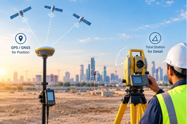
Many clients ask us for a “GPS theodolite” when they need a site marked or measured. It sounds like one smart instrument that does everything. In real survey work, it is usually two tools doing two different jobs. This blog explains the difference in simple words, so you know what to ask for.
1. What Is a Theodolite and How Does It Measure Angles?
- A theodolite measures angles. It reads the horizontal angle (left and right) and the vertical angle (up and down) between two points.
- It sits on a tripod, and the surveyor looks through its telescope at a target.
- It does not give coordinates or distance by itself. It only gives angles.
Older optical theodolites were read by eye from a scale. Modern digital ones show the angle on a screen, but the job is the same.
2. How GPS Adds Accurate Positioning to Survey Work
- GPS (or GNSS, which includes other satellite systems too) tells you where a point is on the earth.
- A survey-grade RTK receiver gives coordinates and height with very small error, often a few centimetres.
- It needs a clear view of the sky. It does not measure angles between points the way a theodolite does.
So one tool answers “which way and how steep”, and the other answers “where on the earth”.
3. Is a GPS Theodolite a Real Instrument?
- There is no standard instrument sold under this name.
- When people say it, they usually mean one of three things:
- a theodolite used together with a GPS receiver
- a total station used with GPS
- a total station with a GPS receiver mounted on it
Some modern total stations can take a GNSS receiver on top. That setup is the closest thing to what people imagine.
4. Why Total Stations Have Replaced the Traditional Theodolite
- A total station is a theodolite with a built-in distance meter.
- It measures angle and distance together, so one setup gives the exact position of every point it sees.
- It saves the readings digitally, so there is no manual booking and fewer mistakes.
- Our GPS Total Station blog explains how the two tools work together.
5. Choosing Between GPS and a Total Station for Your Site
- GPS / RTK: large open areas, boundaries, control points, and long routes. See our GPS Survey service.
- Total station: buildings, tight spaces, setting out, and places where trees, walls or towers block the sky.
- Both together: GPS fixes the site’s position, and the total station does the detailed work from there. This is common in topographic surveys.
6. How GPS and Total Stations Work Together on a Project
- First, the crew uses GPS to set a few control points around the site.
- Then the total station is set up over one of these points and pointed at another.
- From here, every building corner, kerb and level is measured, and all of it ties back to the same coordinate system.
- The result is a drawing that matches the real ground and fits with neighbouring plans.
7. Key Questions to Ask Before Hiring a Survey Company
- Ask which instruments will be used for your project, not only the instrument name.
- Ask how the control points will be fixed and checked.
- Ask what accuracy you can expect, and what file formats you will get.
- Check their equipment list. At ASW, our survey equipment includes 30 total stations, 2 robotic total stations and 6 RTK GPS units.
Conclusion
A “GPS theodolite” is not one special machine. It is an idea: angles from one instrument and satellite position from another. For most projects, the right answer is a total station for detail and GPS for position. Choosing the right tool for the site matters more than the name on the request. If you are unsure what your project needs, contact our team and we will suggest the right method.
FAQ
1. What is a GPS theodolite?
It is not a single standard instrument. The term usually means a theodolite or total station used with a GPS receiver.
2. What is the difference between a theodolite and a total station?
A theodolite measures angles only. A total station measures angles and distance and stores the data.
3. Can GPS replace a theodolite?
Not fully. GPS needs open sky and cannot work well near tall buildings, tunnels or thick tree cover.
4. Which is more accurate, GPS or a total station?
Both can reach survey-grade accuracy. A total station is usually better for close, detailed work.
5. Do surveyors still use theodolites today?
Rarely. Most crews now use total stations, and plain theodolites are mostly used for teaching or simple angle work.