
Introduction
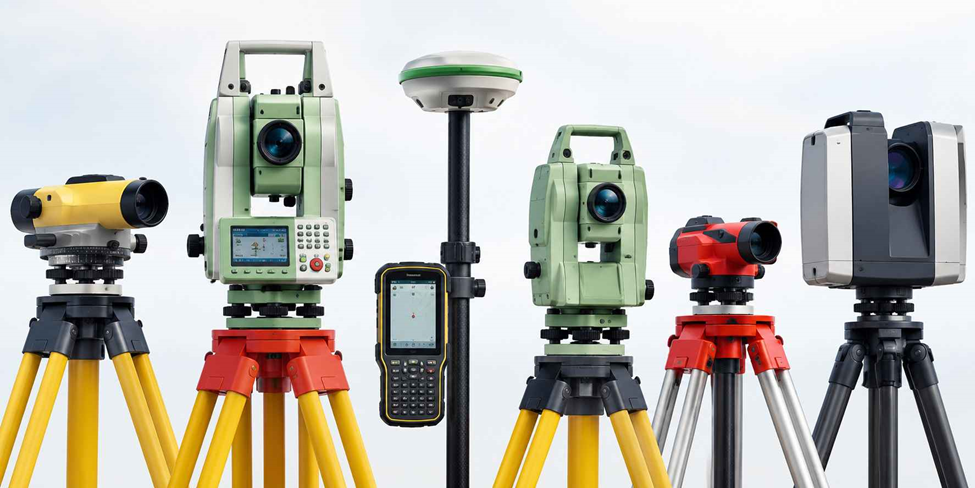
Every survey starts with a question: how accurate does this need to be, and how fast do we need it done? The answer decides which instrument comes out of the case. A boundary dispute that ends up in court demands a different level of rigor than a rough site walk for a feasibility study and the equipment reflects that difference.
This guide covers the instruments a working survey crew actually reaches for, what each one is genuinely good at, where it falls short, and how to match the tool to the job instead of defaulting to whatever’s newest in the truck.
Why the Right Instrument Matters More Than the Newest One
It’s tempting to assume the most advanced piece of land surveying equipment is always the right call. In practice, the opposite is often true. A laser scanner will out-measure a tape by a mile, but if you’re confirming a single boundary corner, setting up and processing a full scan wastes half a day you didn’t need to spend. The instruments below aren’t ranked by sophistication they’re organized by what they’re actually for.
1. Total Station
A total station combines an electronic theodolite with a built-in distance meter, so one setup gives you angle and distance to any point you can see and sight.
Where it earns its keep: Construction layout, boundary staking, and topographic detail work anything where the tolerance is tight and the site is within line-of-sight range of a control point.
In the field: Set the tripod over a known point, level it, and enter your backsight coordinates before taking a single reading. Sight the prism, trigger the shot, and the instrument logs horizontal angle, vertical angle, and slope distance in one go. Robotic models let a single operator run the instrument from the prism pole, which is worth the extra cost on any job where crew size is the bottleneck.
Watch for: Line of sight is non-negotiable. Dense vegetation, structures, or steep terrain between the instrument and the target will stop a total station cold plan your control points with that in mind before you get on site.
2. GNSS/GPS Receiver
A GNSS receiver reads satellite signals to fix a coordinate directly, without needing a clear sightline to a base instrument. RTK correction either from a local base station or a network subscription brings that fix down to centimeter-level accuracy.
Where it earns its keep: Large open parcels, corridor and utility mapping, and control networks that would take a total station crew days to cover on foot.
In the field: Set the base over a known point (or connect to your network correction service), power the rover, and wait for a fixed solution before logging anything a floating fix isn’t tight enough for control work, and it’s a common source of bad data on jobs where crews get impatient. Code each point as you go so it’s identifiable later.
Watch for: Tree canopy, tall buildings, and narrow urban canyons all degrade the satellite signal. On a heavily wooded site, a GNSS-only workflow will frustrate you plan on a total station for anything under cover.
3. Automatic Level
An automatic level does one job and does it well: measuring the difference in elevation between points, using an internal compensator to hold a true horizontal line once it’s roughly set up.
Where it earns its keep: Site grading, drainage design, foundation checks any work that’s purely about height, where you don’t need angle or distance data.
In the field: Level the instrument using the foot screws until the bubble centers, then read a graduated staff held vertically at each point. Keep backsight and foresight distances roughly balanced as you move through a run; it cancels out small instrument errors that would otherwise creep into a long leveling loop.
Watch for: It’s a single-purpose tool. If the job needs angles or horizontal position alongside elevation, a level alone won’t get you there.
4. Theodolite
A theodolite measures horizontal and vertical angles with high precision, without the built-in distance meter a total station carries. That narrower function is exactly why it’s still around a theodolite is lighter, simpler, and less expensive than a total station when angle data is all a job requires.
Where it earns its keep: Triangulation, establishing control points, and alignment surveys where angular precision matters more than an integrated distance reading.
In the field: Center and level over the control point using the optical plummet, zero the horizontal circle against a known reference, then sight and read each target. Taking both a face-left and face-right reading on important points cancels out instrument error that a single reading would miss.
Watch for: Without integrated distance measurement, you’ll need a separate method tape, EDM, or GNSS to capture distances alongside your angles.
5. UAV Survey Drone
A drone fitted with a mapping camera or LiDAR sensor covers ground at a scale no walking crew can match, producing orthomosaic imagery and terrain models from a single flight.
Where it earns its keep: Volumetric surveys on stockpiles and quarries, progress tracking on large construction sites, and initial reconnaissance before ground crews mobilize.
In the field: Plan the flight path and image overlap before takeoff under-planned overlap is the most common reason a processed model comes out with gaps. Fly the mission, then process the captured imagery through photogrammetry software to generate the point cloud, orthomosaic, or surface model.
Watch for: Pilot certification and local airspace restrictions are part of the operating cost, not an afterthought. Factor them into the timeline before you promise a client a drone-based deliverable.
6. 3D Laser Scanner
A terrestrial laser scanner captures millions of points per second, building a dense point cloud rather than a handful of discrete measurements.
Where it earns its keep: As-built documentation, BIM modeling, and industrial or heritage sites where a client needs a full spatial record, not just selected points.
In the field: Position the scanner to cover the target area with minimal occlusion, run the scan, then move to overlapping positions as needed for full coverage. Registration stitching multiple scans into one coordinate system is where most of the post-processing time goes, so budget for it accordingly.
Watch for: The data density is the whole point, but it comes with a processing cost. A scan that takes twenty minutes in the field can easily mean several hours of registration and cleanup before the deliverable is ready.
7. Measuring Tape and Survey Chain
Digital instruments haven’t retired the tape. For short, straightforward distances, it’s often still the fastest tool on site.
Where it earns its keep: Quick boundary checks, small-parcel surveys, and verification measurements where setting up an electronic instrument isn’t worth the time.
In the field: Stretch the tape or chain taut between points and keep it horizontal a reading taken on a slope without correcting for it will throw off the distance. Use a plumb bob at each end when the ground isn’t level, and pin intermediate lengths on longer chain runs.
Watch for: Accuracy depends entirely on technique. A loosely held tape or an uncorrected slope reading introduces error that won’t show up until someone else re-checks the line.
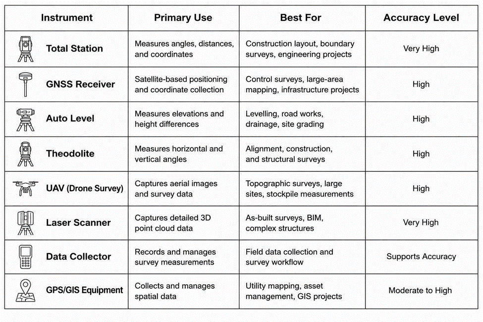
Surveying Instruments Comparison Chart
Data Collectors: Where the Measurements Actually Go
None of the instruments above are useful without a way to capture and manage what they record. A field data collector runs software tied directly to the total station or GNSS receiver, letting the surveyor check point codes, review coordinate geometry, and catch errors in real time while still on site, not after driving back to the office. Catching a bad shot or a missing point before you leave saves a return trip, and on jobs where travel eats into the budget, that’s not a small thing.
Matching Equipment to the Project
GNSS receivers make sense for open parcels and control networks where speed and coverage matter more than sightline precision. Total stations take over where the tolerance is tight and the site allows for direct line of sight construction layout and boundary staking, mainly. Auto levels handle elevation work on their own, without the overhead of a full angle-and-distance instrument. Drones are the right call for large or hard-to-access sites where ground coverage would take too long, and laser scanners step in when the deliverable is a full 3D record rather than a set of discrete points.
Most firms don’t own one of everything. They build a core kit around the survey types they do most often and rent or subcontract for the rest a more realistic approach than trying to stock every instrument on this list.
Calibration and Maintenance
An instrument is only as good as its last calibration. Check total stations and levels against a known baseline on a regular schedule, and calibrate immediately after any drop, rough transport, or exposure to temperature extremes don’t wait for the next scheduled check. Clean lenses and sensors before and after fieldwork, keep batteries charged and tracked, and store instruments in their protective cases between jobs. Firms that let calibration slide tend to find out during a boundary dispute or a construction as-built review, which is the worst possible time to discover a systematic error.
Frequently Asked Questions
What equipment do land surveyors use?
Most survey crews carry some combination of a total station, a GNSS/GPS receiver, an automatic level, and a data collector as their core kit, adding a theodolite, laser scanner, or drone depending on the type of project.
What are the most common surveying instruments?
Total stations, GNSS and GPS receivers, automatic and digital levels, theodolites, laser scanners, UAVs, data collectors, prisms and prism poles, leveling staffs, tripods, and measuring tapes cover the large majority of fieldwork.
What are the main types of surveying?
Land, topographic, boundary, construction, engineering, hydrographic, utility, cadastral, as-built, and route surveying each serve a different mapping or construction purpose, and often call for a different mix of equipment.
What is GPS land survey equipment?
GPS or GNSS survey equipment reads satellite signals to fix precise coordinates in the field. It’s the standard choice for control surveys, large-area mapping, and construction layout on open sites.
How much does land survey equipment cost?
Cost varies widely by instrument and capability. Basic levels are the most affordable entry point, while total stations, GNSS receivers, laser scanners, and survey drones represent a considerably larger investment given the precision and processing power built into them.
Conclusion
The instruments above aren’t interchangeable, and treating them that way is how projects lose time. A total station earns its place on tight-tolerance layout work; a GNSS rover earns its place on open ground; a level earns its place whenever the job is purely about elevation. Knowing which tool fits which task and keeping it properly calibrated is what separates a crew that finishes on schedule from one that’s back on site a second time fixing a measurement that should have been right the first time.
