

If you’re buying land, developing a plot, or settling a boundary dispute in the UAE, you’ve probably come across the term “cadastral survey.” It sounds technical, and it is, but the idea behind it is simple: knowing exactly where your land begins and ends, on paper and on the ground. This guide breaks down what a cadastral survey involves, when you need one, and how the process actually works.
What Is a Cadastral Survey?
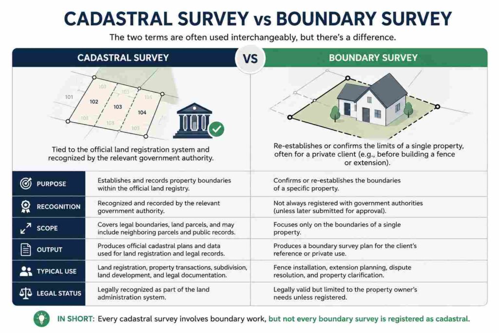
A cadastral survey is the legal measurement and mapping of land parcel boundaries. It establishes the precise coordinates, area, and shape of a property, and ties that data to an official land record, often called a cadastral index map or cadastre. The International Federation of Surveyors (FIG) defines the cadastre as a parcel-based land information system recording interests such as ownership, easements, and restrictions, with the surveyor responsible for establishing and maintaining its boundaries. Unlike a general site survey, a cadastral survey carries legal weight. Its results feed directly into title deeds, land registration documents, and municipal records held by authorities such as the Dubai Land Department.
The surveyor’s job is to locate or re-establish boundary pillars (also called monuments), record their coordinates using a geodetic datum, and confirm that the parcel matches what’s registered. Where old markers are missing, damaged, or disputed, the surveyor recalculates the boundary from historical records and re-monuments the corners.
Why Is a Cadastral Survey Important?
Land in the UAE is registered against fixed coordinates, not just a sketch or a fence line. A cadastral survey protects you in a few concrete ways:
- Legal certainty – your title deed matches the actual ground boundaries, reducing the risk of future disputes.
- Accurate area calculation – developers and buyers pay for, and build on, the exact area registered, not an estimate.
- Encroachment detection – it flags if a neighboring structure, wall, or fence has crept onto your parcel.
- Registration compliance – most land authorities in the UAE, including the Abu Dhabi Department of Municipalities and Transport, require an approved cadastral survey before a title transfer, site plan issuance, or subdivision is processed.
Skipping this step is one of the most common reasons property transactions stall or end up in litigation later.
When Do You Need a Cadastral Survey?
- Before purchasing raw or undeveloped land
- Before subdividing a parcel into smaller plots
- When boundary pillars are missing, shifted, or unclear
- During a dispute with a neighboring landowner
- Before applying for a building permit on a new plot
- When merging two or more adjacent parcels into one title
If any of these apply to you, get the survey done before you sign, build, or file paperwork, not after.
Step-by-Step Cadastral Survey Process
- Document review – the surveyor pulls the existing title deed, previous survey plans, and cadastral index records for the parcel.
- Field reconnaissance – a site visit to locate existing boundary pillars, fences, and any visible discrepancies.
- Control establishment – reference points are set using GNSS observations tied to the national geodetic network.
- Boundary measurement – corners are measured with RTK GNSS receivers and a total station for high-precision traversing.
- Data processing – raw coordinates are adjusted and computed against the official datum.
- Boundary re-establishment – where pillars are missing, corners are recalculated and physically re-monumented.
- Plan preparation – a cadastral plan is drafted showing coordinates, bearings, distances, and parcel area.
- Submission and approval – the plan is lodged with the relevant land department for verification and registration.
Equipment Used in Cadastral Surveys
- RTK GNSS receivers – for centimeter-level positioning tied to satellite constellations
- Total stations – for precise angle and distance measurement between boundary points
- Static GNSS base stations – for establishing long-term control points
- Data collectors and survey-grade software – for field-to-office coordinate processing
- Boundary monuments (pillars/pegs) – physical markers placed at each corner once coordinates are confirmed
Cadastral Survey vs Boundary Survey
Benefits of Professional Cadastral Surveys
- Removes ambiguity from title deeds and sale agreements
- Prevents costly boundary disputes with neighbors
- Speeds up permit and registration approvals
- Gives developers reliable data for subdivision and site planning
- Protects the long-term value of the asset
Why Choose Accurate Survey Work L.L.C.
Accurate Survey Work L.L.C. carries out cadastral and boundary surveys across the UAE using RTK GNSS and total station equipment, with plans prepared to meet local land department submission standards. The team handles everything from pillar re-establishment to final registration support, so property owners and developers get a survey that holds up legally, not just on a drawing.
Conclusion
A cadastral survey isn’t paperwork for its own sake, it’s the foundation that a title deed, a permit application, or a subdivision plan actually rests on. Getting it done properly, before you buy, build, or divide land, saves time, protects your investment, and keeps your registration process moving without surprises.
Frequently Asked Questions.
How long does a cadastral survey take?
Most single-parcel surveys take a few days to two weeks, depending on site access, the condition of existing boundary markers, and how quickly the land department processes approval.
Who is legally allowed to perform a cadastral survey in the UAE?
Only licensed surveyors registered with the relevant municipal or land authority can produce a cadastral survey that’s accepted for official registration.
Does a cadastral survey affect my title deed?
Yes. Once approved, the surveyed coordinates and area become the reference used on your title deed and in the cadastral index.
What happens if my land has no visible boundary pillars?
The surveyor recalculates the corners from historical coordinates and registration records, then re-monuments the boundary on site.
Is a cadastral survey the same as a topographic survey?
No. A topographic survey maps ground features and elevation for design purposes. A cadastral survey maps legal boundaries for registration purposes. Many projects require both.
