
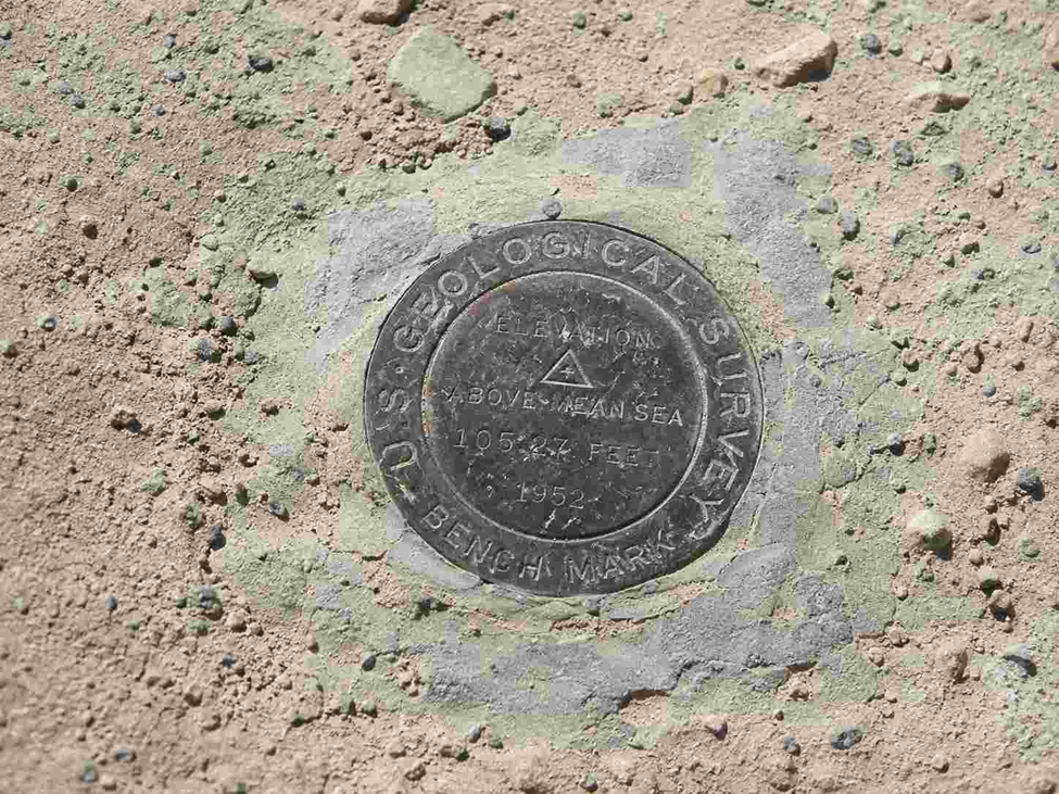
If you’ve ever stood on a construction site watching a surveyor squint through a level, you’ve watched benchmark surveying in action — even if nobody called it that. Every foundation poured, every road paved, and every drainage line laid depends on one quiet, unglamorous idea: knowing exactly how high a point is compared to a fixed reference. Get that wrong, and you get flooded basements, roads that pond water, and floors that don’t quite meet at the doorway.
This guide walks through what a benchmark actually is, the types you’ll run into on real projects, how it connects to Existing Ground Level (EGL), Finished Floor Level (FFL), elevation surveys, road levelling, and site grading — with real numbers, not just textbook definitions. We’ll also cover where professional land survey services fit into all of this, and when it’s worth bringing one in instead of relying on assumed elevations.
What Is a Benchmark in Surveying?
A benchmark is a fixed point of known elevation, measured against a standard datum — almost always Mean Sea Level (MSL). Surveyors use it as the “zero” they trust, then work outward from it using a level and staff to figure out the Reduced Level (RL) of every other point on site. Think of it as the anchor for an entire elevation map; if the anchor is wrong, everything built off it is wrong too.
Why Benchmarks Matter Before You Break Ground
Before excavation starts, engineers need to know how the land currently sits — its highs, lows, slopes, and drainage paths — so they can plan cut-and-fill volumes, foundation depth, and stormwater flow. None of that is possible without a trusted reference elevation. A single reliable benchmark lets an entire project — road, building, canal, or drainage network — stay consistent across months or years of work, even with different survey crews rotating through.
Types of Benchmarks in Surveying
Most surveying references, including Civil Tutorials, group benchmarks into four categories:
- GTS Benchmark (Great Trigonometrical Survey) – The highest-precision type, established by national survey authorities and tied directly to long-term sea-level observations.
- Permanent Benchmark (PBM) – Set up by government agencies on stable, long-lasting structures like bridges, culverts, or public buildings.
- Temporary Benchmark (TBM) – Created for a specific project and used to carry levels forward day to day, often placed on a stable but non-permanent object.
- Arbitrary Benchmark – An assumed elevation used for small, local projects where tying into the national datum isn’t necessary.
In India, GTS benchmarks are especially interesting from a data standpoint: their elevation is derived from tide readings taken over roughly 19 years, a period long enough to average out the 18.6-year lunar nodal cycle and give a genuinely stable mean sea level figure.
Permanent Benchmark vs Temporary Benchmark: The Real Difference
The confusion usually isn’t about definitions — it’s about trust. A permanent benchmark is something you can return to years later and rely on. A temporary benchmark exists only to bridge the gap between two permanent ones during an active survey; once the job’s leveling is verified against a stable point, the TBM’s job is basically done. Treating a TBM as if it were permanent is a common rookie mistake that quietly introduces error into an entire project.
Existing Ground Level (EGL) vs Finished Floor Level (FFL)
These two terms sit right next to each other on every site plan, and mixing them up is expensive:
- Existing Ground Level (EGL) is the natural, current elevation of the land before any construction touches it.
- Finished Floor Level (FFL) is the target elevation of the completed floor slab once construction is done.
The difference between the two tells the contractor exactly how much cut or fill is needed. Get the FFL even a few centimeters wrong relative to EGL, and you risk water pooling against the building, awkward ramp gradients, or a mismatch with the connecting road level.
Elevation Survey: How Surveyors Actually Measure Height Today
Traditional elevation surveys still rely on dumpy levels or auto-levels reading a staff at known intervals, but most active job sites now blend that with total stations and GNSS/RTK receivers for faster, wider coverage. In the U.S., this entire practice sits on top of the National Geodetic Survey’s (NGS) network, maintained by NOAA — a system with more than 1.2 million survey marks placed across the country. Surveyors can search these using the NGS “Data Explorer” tool to find a trusted starting elevation almost anywhere in the U.S.
That said, this infrastructure isn’t indestructible. Illinois’ state geodetic survey has reported that the state has lost nearly half its historical benchmarks over time to construction, farming, and lack of maintenance funding — a good reminder that a benchmark is only useful if it’s actually still there when you go looking for it.
Road Surveying and Levelling: Keeping Highways on Grade
Roads live and die by their longitudinal and cross-sectional gradients. Levelling surveys along a proposed alignment establish RLs at regular chainage intervals, letting designers calculate cut-fill balance, camber, and drainage fall. National standards, like the “Standards and Specifications for Geodetic Control Networks,” recommend benchmark spacing of no more than 3 kilometers along a level line — close enough that errors don’t compound across a long highway stretch.
Site Grading: Turning Raw Land into a Buildable Pad
Site grading is where EGL, FFL, and benchmark data all come together in practice. Grading crews reshape the land — cutting high spots, filling low ones — to hit a target finished elevation that supports proper drainage away from structures, accessible slopes, and a stable base for pavement or foundations. A grading plan is essentially a set of promises about elevation, and every one of those promises traces back to the original benchmark the survey was tied to.
Land Survey Services: When to Bring In the Professionals
Everything above sounds straightforward on paper, but in practice it takes trained hands, calibrated instruments, and legal accountability to get right — which is exactly what licensed land survey services provide. A professional land surveyor doesn’t just take a few staff readings; they establish and certify benchmarks, tie your project into the correct datum, produce stamped elevation and boundary reports, and take on the liability if something’s later disputed in a permit review or property dispute.
You typically need land survey services, rather than an in-house estimate, when:
- You’re establishing a new permanent or temporary benchmark for a site with no reliable existing reference
- Local authorities require a certified elevation survey or topographic survey before approving building plans
- You’re calculating cut-and-fill volumes for site grading and need defensible numbers for cost estimates
- A road or drainage design depends on levelling data that has to hold up over multiple construction phases
- You’re resolving a boundary, easement, or EGL/FFL discrepancy flagged during a site inspection
Professional land surveyors also carry equipment — total stations, GNSS/RTK receivers, and digital auto-levels — that’s calibrated and traceable, which matters if your project ever needs to prove compliance. For most builders, developers, and homeowners, the cost of hiring qualified land survey services is small compared to the cost of correcting a foundation, road, or drainage system built on a wrong elevation.
Common Mistakes That Wreck a Levelling Survey
- Treating a temporary benchmark as permanent and building future surveys off it
- Not double-checking a benchmark’s physical condition before trusting its stated elevation — as seen with the U.S. benchmark-loss data above, markers do get destroyed or shifted
- Mixing up EGL and FFL on drawings, leading to drainage that flows the wrong way
- Skipping a closing check (returning the level loop back to a known point to catch cumulative error)
Need Accurate Benchmark Surveying for Your Project?
Accurate Survey Work L.L.C provides professional benchmark surveying, elevation surveys, and land survey services to support safe and accurate construction. Contact our team today for expert surveying solutions.

Pingback: Marine Survey Accuracy: 10 Factors Affecting Seabed Mapping