
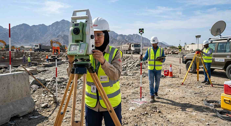
Ground survey equipment encompasses the precision instruments used to measure distances, elevations, angles, and 3D positions on the Earth’s surface prior to and during construction. Selecting the right instrument depends on required accuracy, terrain accessibility, sightlines, and project scale.
Key Surveying Instruments
1. Total Station
A Total Station combines an electronic theodolite with an electronic distance meter (EDM) in a single instrument. It reads horizontal and vertical angles alongside slope distance, then automatically calculates 3D coordinates (X, Y, Z) relative to a known reference point.
How it works: The instrument sends an infrared signal toward a reflective prism or directly at a surface in reflectorless mode to calculate distance and angle simultaneously.
Primary applications:
- Topographic and boundary surveys
- Construction setting-out (staking building corners and gridlines)
- As-built verification for structures, roads, and bridges
2. GNSS (GPS RTK) Receiver
Real-Time Kinematic (RTK) GNSS receivers deliver centimetre-level positioning accuracy in real time by combining signals from multiple satellite constellations GPS, GLONASS, Galileo, and BeiDou with correction data from a base station or network (NTRIP).
How it works: A rover receiver reads satellite signals while a wirelessly transmitted correction stream from a fixed base station refines the position, removing the line-of-sight limits of optical instruments.
Primary applications:
- Ground control point (GCP) establishment
- Utility and pipeline mapping
- Highway, corridor, and land subdivision projects
3. Auto Level
An Auto Level is an optical levelling instrument, tripod-mounted, that holds a true horizontal line of sight once roughly levelled using a circular spirit bubble.
How it works: An internal pendulum compensator automatically corrects small tilts in the line of sight, keeping vertical readings accurate on a graduated levelling staff.
Primary applications:
- Establishing site elevations and benchmarks
- Foundation, floor slab, and drainage slope work
- Earthwork cut-and-fill checks
4. Digital Theodolite
A Digital Theodolite is built specifically to measure horizontal and vertical angles, with a high-resolution digital display replacing the older vernier scale readout.
How it works: Optical or electronic sensors detect angular rotation and provide instant digital readings, accurate to fractions of an arc-second.
Primary applications:
- Column and steel frame alignment
- Bridge pier alignment and tunnel guidance
- High-precision angle checks where distance data isn’t needed
5. 3D Laser Scanner
A terrestrial LiDAR scanner fires hundreds of thousands of laser pulses per second, building dense 3D point clouds that form millimetre-accurate digital replicas of physical spaces.
How it works: The scanner measures laser flight time or phase shift while rotating rapidly, generating millions of geo-referenced 3D points per scan.
Primary applications:
- Scan-to-BIM workflows and reverse engineering
- Complex industrial facility documentation
- Historic preservation and structural deformation monitoring
6. Survey Drone (UAV)
Survey drones carry high-resolution cameras or lightweight LiDAR sensors that cover large areas of land quickly from the air.
How it works: Overlapping aerial photos are processed through photogrammetry software to generate orthomosaics, 3D point clouds, and digital elevation models (DEMs).
Primary applications:
- High-speed topographic mapping of large parcels
- Stockpile volume calculations for quarrying and mining
- Construction site progress monitoring and reporting
Essential Accessories & Field Gear
Every core instrument depends on a supporting set of hardware to capture valid, repeatable data:
- Survey Tripods — Rigid wood, aluminium, or fibreglass bases that keep instruments stable against wind and vibration.
- Survey Prisms — Precision optical corner-cube reflectors mounted on poles that return the Total Station’s EDM signal accurately.
- Survey Poles & Bipods — Calibrated carbon-fibre or aluminium rods that hold prisms or GNSS antennas at a fixed, known height.
- Field Controllers — Ruggedised handheld computers running field data software that let surveyors capture, edit, and export point data on site.
Where Ground Surveying Equipment Is Applied
Ground survey data supports every phase of civil engineering and construction:
- Pre-construction: boundary verification, topographic base maps, environmental mapping, property subdivision
- Design & engineering: alignments for highways, rail networks, bridges, pipelines, and utility infrastructure
- Active construction: earthwork grading, structural staking, anchor bolt positioning, machinery guidance
- Post-construction: as-built documentation, structural health and settlement monitoring, BIM integration
Frequently Asked Questions
What is ground survey equipment used for?
Ground survey equipment is used to measure land features such as distances, elevations, angles, and coordinates. Surveyors use these instruments for topographic mapping, construction setting out, boundary surveys, infrastructure projects, and as-built documentation.
Which instruments are commonly used for ground surveying?
The most commonly used ground surveying instruments include Total Stations, GNSS RTK receivers, Auto Levels, Digital Theodolites, 3D Laser Scanners, and Survey Drones. Each instrument is selected based on the survey requirement, accuracy level, and site conditions.
Why are GNSS RTK receivers used in land surveying?
GNSS RTK receivers provide centimetre-level positioning accuracy by combining satellite signals with real-time correction services. They are commonly used for establishing control points, mapping large areas, utility surveys, and road or pipeline projects.
How do surveyors select the right ground survey equipment for a project?
The selection of ground survey equipment depends on several factors, including project size, required accuracy, terrain conditions, accessibility, and the type of survey work. For example, Total Stations are commonly used for precise construction layout, while GNSS RTK receivers are preferred for large open areas and control surveys.
What factors affect the accuracy of ground survey equipment?
Survey accuracy depends on instrument calibration, environmental conditions, operator skills, satellite availability (for GNSS), stability of setup, and the quality of field procedures. Regular calibration and proper field techniques help maintain reliable survey results.
What is the role of surveying accessories in field measurements?
Accessories such as tripods, prisms, survey poles, and field controllers support accurate data collection. They provide instrument stability, maintain correct measurement heights, and allow surveyors to record and process field observations efficiently.
How does modern survey equipment improve construction accuracy?
Modern survey equipment reduces manual errors by collecting digital measurements, storing field data automatically, and integrating with CAD and BIM software. This helps engineers and contractors maintain accurate positioning throughout the construction process.
