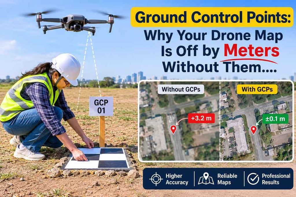
A drone map can look sharp and still sit in the wrong place. The photos are clear, the roads line up, and the colours look right. But the whole map may be shifted by a meter or more. Ground control points are what fix this. Here is how they work, in plain words.
Why a Drone Cannot Fix Its Own Position
- A drone knows where it is only roughly. Its built-in GPS is good for flying, not for survey work.
- Small errors in each photo add up across hundreds of photos.
- The result is a map that is neat but shifted, tilted or stretched.
- Without a fixed reference on the ground, nobody can tell how big the error is.
A drone map is only as good as the points it is tied to. That is the job of ground control points.
What Ground Control Points Look Like on Site
- They are clear markers placed on the ground before the flight. Think of a painted square, a printed target or a mark on the pavement.
- They must be easy to see from the air, so black-and-white or high-contrast patterns work best.
- They stay in one place for the whole flight.
- Each one is measured on the ground with survey-grade equipment, so its position is known very precisely.
The drone photographs the markers. The software then knows exactly where those spots are in the real world.
How Many Points You Need and Where They Go
- A small plot may need only a handful. A long road or a large site needs more.
- Spread them out. Put points near the edges and a few in the middle.
- Avoid putting them all in a straight line. That leaves the map free to bend.
- Place them on flat, open ground. Stay away from shadows, tall walls and places where vehicles park.
- Add a few extra points that are kept aside for checking later.
A good rule is simple. The more the site varies in height and shape, the more points it needs.
How the Points Are Measured and Used
- The survey team measures each marker using a GPS survey method, tied to known reference stations.
- These measured positions are loaded into the mapping software along with the drone photos.
- The software pulls the whole map into the right place, using the markers as anchors.
- The final map matches the real ground in both position and height.
This is how a drone map becomes a survey-grade drawing instead of just a nice picture. To see what comes out at the end, read about our drone mapping service.
How to Check That the Points Did Their Job
- Ask for the check points report. These are markers that were not used to build the map, so they test it honestly.
- Look at the difference between the map position and the measured position. Small numbers mean a good map.
- Compare the map against a few known features, such as a kerb corner or a manhole cover.
- Make sure the report states the coordinate system used.
- For sites that need contours and levels, compare the result with a topographic survey.
If a supplier cannot show you this check, treat the map with care.
Conclusion
Ground control points are small, but they decide whether a drone map can be trusted. They give the map a fixed place in the real world. Skipping them saves a little time on the day and can cost a lot later, when plans, levels or quantities do not match the site. If you are planning a drone survey, ask about the points first. You can also contact Accurate Survey Work to talk through your site.
FAQs
1. What are ground control points?
They are markers placed on the ground and measured precisely, so a drone map can be tied to real positions.
2. Can a drone survey be done without them?
Yes, but the map may be off by meters. It is fine for rough views, not for design or measurement.
3. How many ground control points are needed?
It depends on the site size and shape. Small sites may need five or six. Large or long sites need more.
4. Who measures the points?
A survey team does it, using GPS equipment that gives centimeter-level positions.
5. How do I know the map is accurate?
Ask for a check points report. It shows how far the map is from the measured positions.
ASW already has a control points page, so I linked the main keyword there. I did not open the live site this time. If you want, I can check the pages before you publish.